The History File
NOVEMBER 2017
David Cummings
Common Lands in Christleton
Part 1
Christleton Pit Group volunteers have just completed their latest project at “The Pit” on behalf of the Parish Council. The project which involved stabilising the banks with coir rolls, creating a new footpath and establishing two new fishing platforms, was supported by WREN, the recycling organisation, Cheshire West and Chester Council, Christleton Parish Council and the group itself. The Pit is just one of the three areas of community land managed by the Parish Council. The Village Green and Birch Heath Common are the others, although the King George VI Playing fields are managed by Trustees on behalf on the Parish Council.
In earlier times, common lands were essential elements in the life of the community. Little Heath, better known as The Pit and its surrounds, was one of several areas in the township of Christleton recorded over 200 years ago as a source of sand, gravel and other minerals including clay for brickmaking. The other recorded areas were small parts of four unfenced “wastelands” or heaths (Stamford Heath, Birch Heath, Gibbet Heath and Brown Heath) that were enclosed and taken into private ownership as a result of the “Christleton Inclosure Act of 1794”. The heaths had probably been used for centuries for cattle grazing, pigs and poultry, and had been part of the extensive area of woodland in Christleton mentioned in the Domesday Book. The original trees would have been gradually felled to supply wood for building and tool making, or would have been burnt as firewood; most new saplings would have been eaten by livestock with the result that more hardy plants such as bramble and gorse became more widespread. Regular burning of these newer plants was probably necessary to allow more nutritious plants to develop. Birch trees often spread on areas of ungrazed common, and these were particularly useful source of wood for cottage furniture and for small turned items such as bowls, cotton reels and tool handles.
In medieval times the heaths were called wastelands, but in practice they were by no means wasted as the grazing they provided was vital to the many small scale farmers who had very little enclosed land of their own. The late 18th century was a time of changing fashions, including the desire for personal ownership of all land. It was also a time when the quality of grazing on many heaths deteriorated and when improved farming techniques had made it possible to cultivate marginal land successfully, provided it was carefully controlled, usually within enclosing hedges. These factors led to the enclosure of most commons across the country. We don’t have precise details of the status of each of the common lands in Christleton, but the commons were usually the property of the Lord of the Manor.
The Lord of the Manor for Christleton at this time was Sir John Harper of Caulke Abbey in Derbyshire. The right to use them belonged to the tenants of “ancient enclosures” within the manor, in proportion to the size or value of the enclosure. The same basis was used to divide up common land when it was enclosed. In feudal times the Lord of the Manor would effectively be the owner of all the land in the Christleton township, although officially all land was ultimately owned by the Crown. The Lord would farm part of the land himself; other areas were either farmed by the tenant or were common land and waste. Many of those tenants became freemen, owning some of the land themselves. In addition to land ownership, the Lord would also have legal or social responsibilities, such as upholding of law and order and the maintenance of highways. He also collected taxes, and a major dispute occurred in Christleton in 1772 when Robert Townsend was accused by Sir John Harper of not paying a tax for fish from the Pit at Little Heath since 1711.
In Christleton the four heaths, totalling about 270 acres, were enclosed in 1794; of this total 35 acres sold to Robert Townsend to pay the enclosures commissioners’ and surveyors’ expenses. 78 acres were allotted to Thomas Brock, the then Lord of the Manor, 43 acres were allotted to Robert Townsend and 10 to the Rector. The remaining 104 acres were divided among 31 claimants, 11 of whom received less than half an acre. To be continued.
With special thanks to Eric Kenyon for his original research, writing & mapping.
Reference:
Christleton 2000 Years of History;
Published by Christleton Local History Group 2000
-

Little Heath Pit Common Land
-

Cattle drinking a Christleton Pit 1907
-

Christleton Pit Team Octobr 2017
-

Christleton Village Green 1907
-

Heathland around Christleton township
-

Christleton Pit Commemorative Plaque
-

Tithe barn, Christleton
-

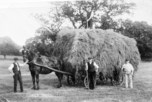
Haymaking on Christleton Common
-

Ploughing
-

Big fish in Christleton Pit
-

Big fish in Christleton Pit
-

New path and fishing platform, Christleton


-

Land in Christleton in 1752
-

Christleton Land in 1794 and 1844

